SHAWNIGAN WATER.ORG
  • Home
  • ABOUT
    • SHAWNIGAN BASIN SOCIETY
    • ECOLOGICAL DESIGN PANEL
  • PROJECTS
    • Past Projects >
      • Natural Edge Program
      • Foreshore >
        • Foreshore to Forest
      • Milfoil
      • EBCP
      • Incorporation
      • SOIL DEPOSITS
  • Get Involved
    • WAYS TO SHOW YOUR SUPPORT
    • STEWARDSHIP
  • Events
  • Reports
  • MAPS & RESOURCES
    • SBS MAPPING >
      • COMMUNITY
      • VEGETATION CHANGES >
        • A Tale of Two Watersheds
        • Shawnigan Watershed Changes
  • Contact Us

 Shawnigan Basin Society Mapping Projects 

The Basin Society has a collection of maps to share with the community.  
Click on the links below to learn more about each mapping project.
LAND USE: TERESTRIAL IMPACTS
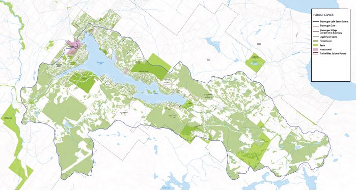
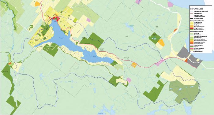
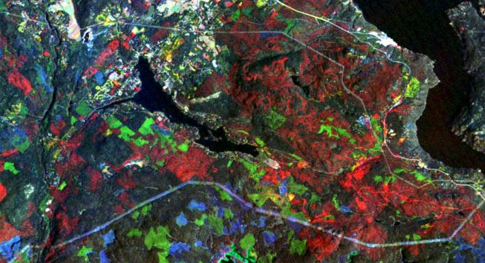
​LandSat Maps of Change: More Than Just Pretty Pictures

​
A Master's thesis on the vegetation changes between 1984 and 2014 in Shawnigan Lake
​This study mapped the vegetation changes between 1984 and 2014 in southern Vancouver Island using various methods, including the Normalized Differential Vegetation Index (NDVI) derived from satellite data.  Very detailed analyses in the Shawnigan Lake Watershed during those 31 years provide information on vegetation cover, urban sprawl, and remaining ecological corridors.
​As climate in the region continues to change and anthropogenic pressures build-up, mapping the changing landscape becomes critical for the adaptive management of the basin.​
 
© Mar Martínez de Saavedra Álvarez, MSc.
bio- physical aspects
Picture
COMMUNITY
Picture
Vegetation Changes
Picture
Maps create by EKISTICS
commissioned by TimberWest
​(Couverdon) providing information
​on land forms, forest and aquifer.

Read Report
Maps create by EKISTICS commissioned by TimberWest (Couverdon) providing information on official community plan, zoning, and sanitary infrastructure.

Maps create by Mar Martínez using 31 years of LandSat data to provide information on vegetation cover, urban sprawl, and remaining ecological corridors. 
​ *All maps are GIS compatible*
READ thesis

 Web Design by VedaWorks and the Shawnigan Basin Society
Proudly powered by Weebly
  • Home
  • ABOUT
    • SHAWNIGAN BASIN SOCIETY
    • ECOLOGICAL DESIGN PANEL
  • PROJECTS
    • Past Projects >
      • Natural Edge Program
      • Foreshore >
        • Foreshore to Forest
      • Milfoil
      • EBCP
      • Incorporation
      • SOIL DEPOSITS
  • Get Involved
    • WAYS TO SHOW YOUR SUPPORT
    • STEWARDSHIP
  • Events
  • Reports
  • MAPS & RESOURCES
    • SBS MAPPING >
      • COMMUNITY
      • VEGETATION CHANGES >
        • A Tale of Two Watersheds
        • Shawnigan Watershed Changes
  • Contact Us