SHAWNIGAN WATER.ORG
  • Home
  • ABOUT
    • SHAWNIGAN BASIN SOCIETY
  • Natural Edge Program
  • PROJECTS
    • Past Projects >
      • Foreshore >
        • Foreshore to Forest >
          • Upland Forests
      • Milfoil
      • EBCP
      • Incorporation
      • SOIL DEPOSITS
  • Get Involved
    • WAYS TO SHOW YOUR SUPPORT
    • STEWARDSHIP
  • Events
  • Reports
  • MAPS & RESOURCES
    • SBS MAPPING >
      • COMMUNITY
      • VEGETATION CHANGES >
        • A Tale of Two Watersheds
        • Shawnigan Watershed Changes
  • Contact Us

Monitoring Vegetation Changes in the Shawnigan Watershed with Remote Sensing: A Study in Support of Adaptive Management and Ecological Governance​​


Mar Martínez  de Saavedra Álvarez, M.Sc.

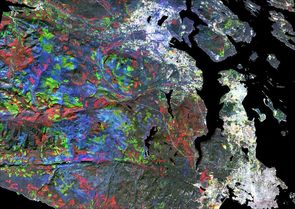
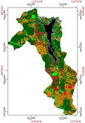
The main objective of my Master’s thesis was to contribute to the body of knowledge required for the science-based adaptive management of the basin by investigating the use of satellite imagery to map vegetation changes in the Shawnigan Watershed from 1984 to 2014, and to characterize its current condition.
As climate in the region continues to change and anthropogenic pressures build-up, mapping the changing landscape becomes critical for the adaptive management of the basin.
Read Document

A Tale of Two Watersheds
SHAWNIGAN WATERSHED CHANGES
Picture
Picture

 Web Design by VedaWorks and the Shawnigan Basin Society
Proudly powered by Weebly
  • Home
  • ABOUT
    • SHAWNIGAN BASIN SOCIETY
  • Natural Edge Program
  • PROJECTS
    • Past Projects >
      • Foreshore >
        • Foreshore to Forest >
          • Upland Forests
      • Milfoil
      • EBCP
      • Incorporation
      • SOIL DEPOSITS
  • Get Involved
    • WAYS TO SHOW YOUR SUPPORT
    • STEWARDSHIP
  • Events
  • Reports
  • MAPS & RESOURCES
    • SBS MAPPING >
      • COMMUNITY
      • VEGETATION CHANGES >
        • A Tale of Two Watersheds
        • Shawnigan Watershed Changes
  • Contact Us